About
Taiwan Operational Meteorology-Ocean Observing Network (TOPMOON)

People

Principal Investigators :
Sen Jan
Professor at Institute of Oceanography, National Taiwan University
Je-Yuan Hsu
Assistant Professor at Institute of Oceanography, National Taiwan University
Wei-Yu Chang
Associate Professor at Department of Atmospheric Sciences, National Central University
Ming-Huei Chang
Professor at Institute of Oceanography, National Taiwan University
Yu-Hsin Cheng
Assistant Professor at Department of Marine Environmental Informatics, National Taiwan Ocean University
Dong-Lin Li
Assistant Professor at Department of Electrical Engineering, National Taiwan Ocean University
Project Manager :
I-Chang Liu
Institute of Oceanography, National Taiwan University
Project Coordinator :
Wei-Ting Tien
Institute of Oceanography, National Taiwan University

A short description for TOPMOON

The establishment of a meteorology-ocean observing network is motivated by the long-term lack of a systematic ocean observing network in the sea surrounding Taiwan, and is urgent to improve the infrastructure of fundamental ocean and meteorological research and outposts for disaster mitigation using real-time data transmission technology. We propose a four-year work plan to achieve the objectives of TOPMOON, including supporting ocean-atmosphere scientific research, advancing marine disaster early warning ability, and reducing social impacts from extreme oceanic events. Operational data buoy system, vessel-mounted meteorological radar, real-time data transmission for deep sea instruments, concurrent underwater gliders observation ability, and value-added multi-satellite data will be built along with the project with supports of existing observational resources and technologies from the academic community in Taiwan. Oceanic talent cultivation and connection to the global ocean observing system (GOOS) will be beneficial from the operation of TOPMOON.

Keywords: prototype operational ocean meteorology value-added

Background

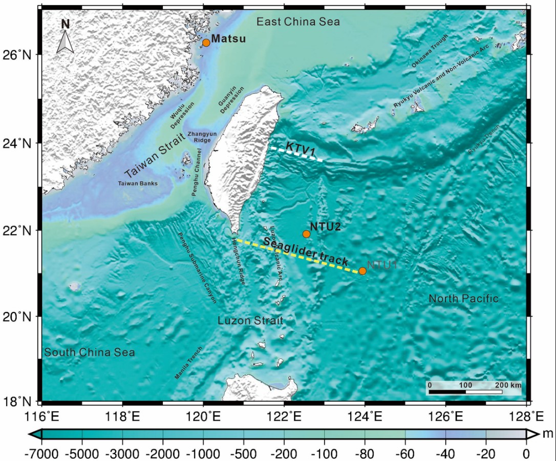
Located in the junction of the Eurasia and Philippine Sea plates and in the western boundary of the North Pacific (Fig. 1), Taiwan is beneficial from the biological and non-biological resources in the surrounding seas, and also suffers from typhoons, earthquakes, and global warming from the ocean. In addition to energetic geological activities (Sibuet et al., 2005; among others), the surrounding seas of Taiwan are influenced by the western boundary current of the North Pacific, Kuroshio, westward-propagating mesoscale eddies (e.g., Chelton et al., 2007; Yang et al., 2013; Cheng et al., 2014, 2017; Chang et al., 2015; Jan et al., 2017; Chang et al., 2018) and typhoons (e.g., Jan et al., 2017; Yang et al., 2019), resulting in a sensitive and complicated marine environment. From the management of marine resource and the mitigation of marine disaster points of view, a complete knowledge of oceanography based on comprehensive field observations is the key to the success (e.g., Cheng and Chang, 2018). On the land of Taiwan, we have established complete earthquake monitoring and meteorological observing networks. Comparing with the two networks, similar observations are still meager in the ocean, particularly, east of Taiwan. The long-term lack of a sustainable ocean observing network in the sea surrounding Taiwan motivates the idea of this integrated project. The establishment of the operational four-dimensional meteorology-ocean observing network (TOPMOON) as an infrastructure of fundamental ocean and meteorological research is crucial to an outpost for disaster mitigation using real-time data transmission technology. The urgent need for establishing such an observing network for Taiwan is clear.

...
Fig. 1 Bathymetry in the seas surrounding Taiwan.

In the complicated dynamics between the atmosphere and ocean, the wind forcing at the air-sea interface, which can be modulated by surface waves, can significantly affect the upper ocean structure, and thereby sea surface temperature (SST) variations. More and more atmosphere-wave-ocean coupled models are thus proposed and operated for the daily weather forecast, such as ECMWF. Compared to the traditional atmosphere-ocean coupled models, simulating surface wave dynamics during the model runs can affect the momentum and thermal flux exchange. As an island located in the northwest Pacific, the ocean near Taiwan is a hot spot for the passage of typhoons from summer to autumn annually. Because the ocean is the energy source for most weather systems, including typhoons, assimilating in-situ atmospheric and wave measurements can directly enhance the model performance. Moreover, even if the storm wind does not directly cause the loss of human properties, strong waves and storm surges can travel a long distance and affect the fishery and coastlines around Taiwan. Therefore, establishing a long-term database including marine meteorology and surface waves can benefit model forecasts on the weather systems and sea state around Taiwan.

Goals

1
To construct a prototype of Taiwan’s ocean observing network.
2
To integrate existing marine observation resources into the network.
3
To establish and maintain operational far field and near field buoy observations (one in the western North Pacific, and the other one off Matsu close to the mainland China coast).
4
To systemize meteorological, sea surface waves, and radar observations on board research vessels, including operation, maintenance, and data management.
5
To cooperate with the Marine Instrument Center to join the international boundary ocean observing network (BOON) using Seagliders (Testor et al., 2019) and strengthen the operation of autonomous underwater vehicle.
6
To develop underwater data transmission and communication technologies.

Tasks

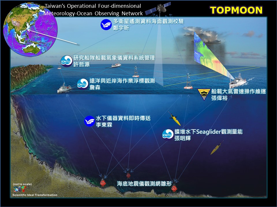
The associated tasks for achieving these goals comprise the coordination of six principal investigators from National Taiwan University (NTU), National Central University (NCU), and National Taiwan Ocean University (NTOU) being responsible for the deployment, maintenance, and recovery of data buoys, strengthening of ship-based meteorological and wave observations, improvement of marine geophysical measurements, international cooperation of glider observations, and development of underwater acoustic modem for data transmissions and communications (see a conceptual diagram in Fig. 2). The main-project aims to create a platform for these principal investigators to work together and to perform and sharpen their expertise in these different disciplinary. This is also crucial for cultivating seagoing oceanographers of next generation. Doubtlessly, these mission-oriented tasks are fundamental (but not full) components in a meteorology-ocean observing network. The in-situ observations and real-time data transmission proposed by the project are important to improve the national disaster (particularly from the ocean) early warning ability and could be beneficial to the associated disaster mitigation. The observational data will be processed, quality-assured, and value-added in a project data website and in collaboration with Taiwan’s Ocean Data Bank. The field data obtained from TOPMOON at a ship-based long-term observation section across the Kuroshio KTV1 line, a fixed glider observing track, two long-term data buoys NTU2 and Matsu (Fig. 1), fundamental ocean bottom geophysical observations, etc. will be used to supplement associated scientific research in (but not limited to):

Air-sea momentum, heat, and water exchange under extreme weather events
Ocean responses to typhoons and the evolving dynamics
Northeasterly cold surge and the impact on the ocean in winter
Energy exchange between mesoscale eddies and turbulence
Eddy-Kuroshio interaction
Submesoscale processes and energy cascade in the ocean
Tectonic plate activities and earthquakes
Assessment of variability in the ocean under the influence of climate change
Ocean’s role in the global biogeochemical cycle and carbon budget

The data collected by TOPMOON will also be a basic state of the marine environment around Taiwan as well as western North Pacific for the assessment of impact from the climate change to the ocean. In addition to the research applications, the value-added products will be provided to the associated government agencies such as the Central Weather Bureau and National Science and Technology Center for Disaster Reduction of Taiwan in a timely mode.

...
Fig. 2A conceptual diagram showing the integrated universities and interdisciplinary collaboration of TOPMOON.

Expect achievements

Improving oceanic and atmospheric observing infrastructures to supplement associated research.
Providing in-situ truth for validating both oceanic and atmospheric numerical simulations.
Advancing the marine hazard early warning system.
Improving associated disaster mitigation.
Reducing potential social impacts from extreme oceanic events.
Connecting to the global ocean observing system (GOOS) (Thurston et al., 2021).
Validating satellite SST, Chl-a, and wind speed using multi-observations.
Establishing a refined Chl-a and wind speed retrieval algorithm.
Achieving underwater data transmission.
Cultivating oceanic talent and seagoing technicians.

Work plan

TOPMOON plans to build two operational data buoy systems, install vessel-mounted Doppler radar scanning system, conduct concurrent underwater gliders observations, validate satellite-derived sea surface wind and wind waves using the field data of this project, and establish real-time data transmission for deep sea instruments.

The anchored data buoy is aimed particularly at providing in-situ near sea surface atmosphere and upper ocean hydrographic profile observations during the passage of a typhoon as initial conditions to numerical typhoon forecast.
The ship-based observation is aimed at enhancing underway meteorology and sea surface state measurements of the nation’s research vessel fleet.
To continue autonomous underwater vehicle. The gliders make oceanographic measurements similar to those collected by research vessels and moored instruments, but at a much low cost. Seaglider has been operated by many teams all over the world that have developed operating systems capable of piloting their gliders and transmitting their data through Iridium satellite-based communications (see Testor et al., 2019).
To establish long range marine radar observations on board R/V New Ocean Researcher 1. The shipborne meteorological radar with dual-polarimetric capability has shown can provide more detailed information of precipitation particles (SEA-POL, Rutledge et al., 2019). The shipborne meteorological radar on board R/V New Ocean Researcher 1 along with other atmospheric and maritime instruments can provide a valuable opportunity to characterize not only the maritime precipitation systems but also the air-sea interaction.
The observing network will be naturally incorporated with the existing observational resources and technologies from Taiwan’s academic community. Any of the instruments and technologies built by TOPMOON will be certainly shared to the community after the completion of the project. Note that, again, TOPMOON is keen to establish a prototype of atmosphere-ocean observing network for Taiwan.

Support

Office/laboratory space and facilities from each participating institution or department
Administrative supports from each participating institution or department
Ship-time for seagoing operations from the National Science and Technology Council
Certain manpower for associated field works from each participating institution or department

References

Chang, Y., Miyazawa, Y., and Guo, X. (2015). Effects of the STCC eddies on the Kuroshio based on the 20-year JCOPE2 reanalysis results. Prog. Oceanogr., 135, 64-76, doi: 10.1016/j.pocean.2015.04.006.
Chang, M.-H., Jan, S., Mensah, V., Andres, M., Rainville, L., Yang, Y. J., and Cheng, Y.-H. (2018). Zonal migration and transport variations of the Kuroshio east of Taiwan induced by eddy impingements. Deep-Sea Research I, 131, 1-15. https: //doi.org/10.1016/j.dsr.2017.11.006
Chang, W.-Y., J. Vivekanandan, T.C.C. Wang (2014). Estimation of X-Band Polarimetric Radar Attenuation and Measurement Uncertainty Using a Variational Method. J. Appl. Meteor. Climatol., 53, 1099–1119.
Chang, W.-Y., W.-C. Lee, and Y.-C. Liou (2015). The Kinematic and Microphysical Characteristics and Associated Precipitation Efficiency of Subtropical Convection during SoWMEX/TiMREX. Mon. Wea. Rev., 143, 317–340.
Chang, W.-Y., J. Vivekanandan, K. Ikeda, P.-L. Lin (2016). Quantitative Precipitation Estimation in Epic Colorado Flood Event of September 2013: Polarization Radar-based Variational Scheme. J. Appl. Meteor. Climatol., 55, 1477-1495.
Chelton, D. B., Schlax, M. G., Samelson, R. M., and de Szoeke, R. A. (2007). Global observations of large oceanic eddies. Geophys. Res. Lett., 34, L15606, doi:10.1029/2007GL030812.
Cheng, Y.-H., Ho, C.-R., Zheng, Q., and Kuo, N.-J. (2014). Statistical Characteristics of Mesoscale eddies in the North Pacific derived from satellite altimetry. Remote Sensing, 6, 6, 5164-5183. doi:10.3390/rs6065164.
Cheng, Y.-H., Ho, C.-R., Zheng, Bo, Q., Hu, J., and Kuo, N.-J. (2017). Statistical features of eddies approaching the Kuroshio east of Taiwan Island and Luzon Island. J. Oceanogr., doi:10.1007/s10872-017-0411-7.
Cheng, Y. -H., and Chang, M. -H. (2018). Exceptionally cold water days in the southern Taiwan Strait: their predictability and relation to La Nina, Natural Hazards and Earth System Sciences, 18 (7), 1999-2010.
Clarizia, M.P. and C.S. Ruf (2016). Wind Speed Retrieval Algorithm for the Cyclone Global Navigation Satellite System (CYGNSS) Mission. IEEE Trans. Geosci. Remote Sens., 54, 4419–4432.
Demott, C. A., and S. A. Rutledge (1998). The vertical structure of TOGA COARE convection: Part I. Radar echo distributions. Journal of the Atmospheric Sciences, 55, 2,730–2,747.
Gao, Y., T. Rojas, K. Wang, S. Liu, D. Wang, T. Chen, H. Wang, A. T. Ngo, and D. Wang (2020). Low-temperature and high-rate-charging lithium metal batteries enabled by an electrochemically active monolayer-regulated interface, Nature Energy, vol. 5, pp. 534-542.
Garrison, J. L. S. J. Katzberg, and M. I. Hill (1998). Effect of sea roughness on bistatically scattered range coded signals from the Global Positioning System, Geophys. Res. Lett., 25, 13, 2257–2260.
Gleason, S. (2013). Space based GNSS scatterometry: Ocean wind sensing using empirically calibrated model, IEEE Trans. Geosci. Remote Sensing, 51, 9, 4853–4863.
Hayes, S.P., L.J. Mangum, J. Picaut, A. Sumi, and K. Takeuchi (1991). TOGA TAO: A moored array for real-time measurements in the tropical Pacific Ocean. Bull. Am. Meteorol. Soc., 72, 339–347.
Houze, R.A. Jr. (1977). Structure and dynamics of a tropical squall line system. Monthly Weather Review, 105, 1540–1567, https://doi.org/10.1175/ 1520-0493
Jan, S., Wang, J., Chern, C.-S., and Chao, S.-Y. (2002). Seasonal variation of the circulation in the Taiwan Strait. Journal of Marine Systems, 35, 3-4, 249-268, doi:10.1016/S0924-7963(02)00130-6.
Jan, S., Sheu, D. D., and Kuo, H.-M. (2006). Water mass and throughflow transport variability in the Taiwan Strait. Journal of Geophysical Research–Oceans, 111, C12012, doi:10.1029/2006JC003656
Jan, S., Mensah, V., Andres, M., Chang, M.-H., and Yang, Y. J. (2017). Eddy-Kuroshio interactions: Local and remote effects. Journal of Geophysical Research: Oceans, 122, https://doi.org/10.1002/2017JC013476.
Jan, S., Yang, Y. J., Chang, H.-I, Chang, M.-H. Chang, and Wei, C.-L. (2017). New data buoys watch typhoons from within the storm. Eos, 98, https://doi.org/10.1029/2017EO069821.
Jan, S., S. -H. Wang, K. -C. Yang, Y. -J. Yang, & M. -H. Chang (2019). Glider observations of interleaving layers beneath the Kuroshio primary velocity core east of Taiwan and analyses of underlying dynamics. Scientific Reports, 9, 11401.
Lindstrom, E., Bryan, F., & Schmitt, R. (2015). SPURS: Salinity processes in the upper-ocean regional study: The North Atlantic experiment. Oceanography, 28(1), 14-19
Liou, Y.-C., and Y.-J. Chang (2009). A variational multiple Doppler radar three-dimensional wind synthesis method and its impacts on thermodynamic retrieval. Mon. Wea. Rev., 137, 3992–4010.
Pelland, N. A., Eriksen, C. C., and Cronin, M. F. (2016). Seaglider surveys at Ocean Station Papa: Circulation and water mass properties in a meander of the North Pacific Current, J. Geophys. Res. Oceans, 121, 6816–6846.
Rickenbach, T. M., and S. A. Rutledge (1998). Convection in TOGA COARE: Horizontal scale, morphology and rainfall production. Journal of the Atmospheric Sciences, 55, 2715–2729.
Rudnick, D. L., S. Jan, L. Centurioni, C. M. Lee, R.-C. Lien, J. Wang, D.-K. Lee, R.-S. Tseng, Y. Y. Kim, and C.-S. Chern (2011). Seasonal and mesoscale variability of the Kuroshio near its origin. Oceanography 24(4): 52–63.
Ruf, C. S., S. Gleason, Z. Jelenak, S. Katzberg, A. Ridley, R. Rose, J. Scherrer, and V. Zavorotny (2012). The CYGNSS nanosatellite constellation hurricane mission. in Proc. IEEE Int. Geoscience Remote Sensing Symp., Munich, Germany, 214–216.
Rutledge, S. A., Chandrasekar, V., Fuchs, B., George, J., Junyent, F., Kennedy, P., & Dolan, B. (2019). Deployment of the SEA-POL C-band Polarimetric Radar to SPURS-2. Oceanography, 32(2), 50-57.
Stroe, Daniel-Ioan (2014). Lifetime Models for Lithium Ion Batteries used in Virtual Power Plants, Ph.D. dissertation, Dept. of Energy Technology, Aalborg University.
Suthar, B., D. Sonawane, R.D. Braatz, V. R. Subramanian (2015). Optimal low temperature charging of lithium-ion batteries," 9th IFAC Symposium on Advanced Control of Chemical Processes ADCHEM, 48, 8, 1216-1221.
Testor, P., Meyers, G., Pattiaratchi, C., Bachmayer, R., Hayes, D., Pouliquen, S., et al. (2010). “Gliders as a component of future observing systems,” in Proceedings of OceanObs’09: Sustained Ocean Observations and Information for Society (Vol. 2), eds J. Hall, D. E. Harrison, and D. Stammer (Venice: ESA Publication), 21–25.
Testor, P. et al. (2019). OceanGliders: a component of the integrated GOOS. Frontiers in Marine Science. https://doi.org/10.3389/fmars.2019.00422.
Thurai, M., May, P. T., & Protat, A. (2014). Shipborne polarimetric weather radar: impact of ship movement on polarimetric variables at C band. Journal of Atmospheric and Oceanic Technology, 31(7), 1557-1563.
Thurston, S. et al. (2021). The Global Ocean Observing System: Oceans of data for earth system predictions. World Meteorological Organization Bulletin, 70, 2, https://public.wmo.int/en/resources/bulletin/global-ocean-observing-system-oceans-of-data-earth-system-predictions
Tippmann, S., D. Walper, L. Balboa, B. Spier, and W. G. Bessler (2014). Low-temperature charging of lithium-ion cells part I: Electrochemical modeling and experimental investigation of degradation behavior. Journal of Power Sources, 252, 305-316.
Vivekanandan, J., S. M. Ellis, R. Oye, D. S. Zrnic, A. V. Ryzhkov, and J. Straka (1999). Cloud microphysics retrieval using S-band dual-polarization radar measurements. Bull. Amer. Meteor. Soc., 80, 381–388.
Yang, G., Wang, F., Li, Y., and Lin, P. (2013). Mesoscale eddies in the northwestern subtropical Pacific Ocean: Statistical characteristics and three-dimensional structures. J. Geophys. Res. Oceans, 118, 1906-1925, doi:10.1002/jgrc.20164.
Yang, Y. J., Chang, M.-H., Hsieh, C.-Y., Chang, H.-I, Jan, S., and Wei, C.-L. (2019). The role of enhanced velocity shears in rapid ocean cooling during Super Typhoon Nepartak 2016. Nature Communications, doi: 10.1038/s41467-019-09574-3.
Yang, X. G., G. Zhang, S. Ge, and C.Y. Wang (2018). Fast charging of lithium-ion batteries at all temperatures. Proceedings of the National Academy of Sciences (PNAS), Vo. 115, No. 28, pp. 7266-7271.
Zavorotny, V. U. and A. G. Voronovich (2000). Scattering of GPS signals from the ocean with wind remote sensing application, IEEE Trans. Geosci. Remote Sensing, 38, 1, 951–964.