Chief Scientist
Sen Jan
Yiing Jang Yang
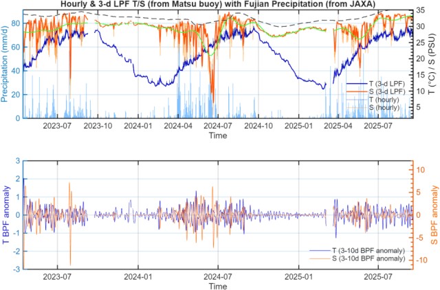
Climate change has significantly increased the frequency and intensity of extreme oceanic and atmospheric hazards, including typhoons, storm surges, extreme waves, rogue waves, and hazardous coastal currents. For example, Matsu buoy deployed near the northwestern coast of Nangang (see Fig. 1 for its location) recorded extremely low salinity during June 2024 (Fig. 2). The low salinity water was from the excess high discharge of the Minjiang River, which was conceivably induced by an extreme heavy rainfall event in southeastern China during June 2024. Indeed, Matsu can be an outpost for monitoring coastal environment and China Coastal Current in winter (Jan et al., 2002, 2006). Any variability in the marine environment of the buoy sites can conceivably affect the surrounding waters of Taiwan. Therefore, accurate prediction and early warning of such events require sustained, high-quality, real-time atmosphere–ocean observations with vertical resolution and operational reliability.
The first phase of TOPMOON established the operational meteorology–ocean observing network with three offshore remote buoys and three coastal environment monitoring stations (ref. Fig. 1). Building upon this foundation, Real-Time Met-Ocean Observing Network 2.0 aims to not only upgrade the hardware, data reliability, underwater communication capability, and operational resilience of the existing system. The upgraded network will provide the observational backbone for AI-driven ocean forecasting and hazard early warning under TOPMOON-II. Three integrated components are proposed to achieve:
- Surface buoy platform (NTU-Seawatch series, Fig. 2)
- Subsurface instrumentation and acoustic telemetry
- Cloud-based real-time data integration
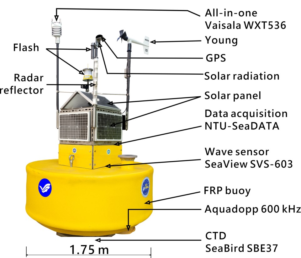
The NTU-Seawatch buoy system is designed as a robust, multi-parameter observation platform, which will be upgraded with (a) EPS core (20K density) internal flotation structure, (b) stainless steel (SUS) central load-bearing frame, (c) dual cylindrical ports for current profiling, (d) polyester resin laminated outer shell, (e) Dyneema high-strength mooring lines, and (f) central SUS battery chamber for stability control. The pair of underwater acoustic modems will transmit seabed temperature, salinity, and pressure to the modem mounted on the bottom of the surface buoy acoustically, which then relays the data via 4G/Iridium to the cloud.
The buoy provides sufficient buoyancy (~1322 kg net buoyant force) to support multi-sensor payloads while maintaining stability under extreme weather conditions. The data buoy will collect the meteorological and oceanic parameters every 10 minute, including: (1) Barometric pressure, (2) Wind speed and direction, (3) Air temperature and relative humidity, (4) Precipitation, (5) Solar radiation, (6) Significant wave height, period, and direction, (7) GPS position, (8) Current velocity profile, (9) Temperature and salinity below the sea surface and above the sea bottom, and (10) Bottom pressure. All sensors are interfaced with a low-power datalogger system and integrated with automated QC routines. Importantly, to further transform the buoy into a coupled physical–biogeochemical observatory, the following sensors will be appended step-by-step:
- pH sensor
- Dissolved Oxygen (DO)
- Chlorophyll-a fluorometer
- Turbidity sensor (future expansion)
The addition of coastal monitoring stations at Bitou (northeastern Taiwan), Penghu (Taiwan Strait), Green Island, and Lanyu (southeastern offshore islands) is strategically designed to enhance the spatial coverage (see Fig. 1) and dynamic representativeness of TOPMOON-II. These sites occupy key oceanographic and atmospheric transition zones: Bitou is influenced by the Kuroshio–coastal current interaction and frontal variability; Penghu is located within the Taiwan Strait where strong tidal currents, South China Sea surface warm current in summer, Kuroshio branch current coming from the south in winter, as well as monsoon-driven China Coastal Current in winter dominate (Jan et al., 2002); Green Island and Lanyu are directly exposed to the Kuroshio main stream and are frequently impacted by typhoons and extreme waves. Establishing real-time met-ocean and biogeochemical monitoring stations at these locations will strengthen cross-shelf and along-current observations, improve detection of extreme events (e.g., storm surge, rogue waves, hazardous currents), and provide critical validation data for AI-driven forecasting systems. Furthermore, these stations will enable integrated monitoring of coral reef ecosystems and coastal environmental changes under climate variability. Collectively, the expanded coastal network will bridge offshore observations with nearshore hazard monitoring, significantly improving early-warning capability and regional ocean–atmosphere coupling diagnostics within TOPMOON-II.
To strengthen basin-scale and regional air–sea coupling observations under TOPMOON-II, we plan to request an annual 30-day R/V Legend cruise along the Taiwan–Guam–Palau–Taiwan track (yellow lines in the inset on the lower-right of Fig. 1) each spring. This transect strategically crosses the western North Pacific Kuroshio region, North Equatorial Current, and eddy-rich waters between the first and second island chains, enabling large-scale observation of submesoscale processes, mesoscale eddies, upper-ocean heat content, biological effect in and outside of an eddy, ocean stratification, and air–sea interaction processes.
n addition, a 24-day annual R/V New Ocean Researcher 1 cruise will be conducted to perform intensive ocean–atmosphere joint observations around Dongsha Atoll and the northern Taiwan Strait. This region represents a dynamically complex environment influenced by Kuroshio intrusion, monsoonal forcing, internal solitary waves, and strong tidal currents. The cruise will integrate high-resolution hydrographic surveys, atmospheric flux observations, and biogeochemical sampling to improve understanding of air–sea coupling, and reef ecosystem vulnerability. Together, these two ship-based campaigns will provide essential cross-basin and regional validation datasets, enhance AI-ready model assimilation, and significantly strengthen TOPMOON-II’s predictive capability for climate variability and marine hazards.
Goals
- Year 1 :
-
(a) Retrofit existing NTU-Seawatch buoys to Network 2.0 structural specifications;
(b) Install upgraded meteorological and oceanographic sensor suites;
(c) Deploy pilot biogeochemical sensor (pH). - Year 2 :
-
(a) Expand deployment to additional strategic coastal sites (Bitou, Penghu, Green Island, Lanyu);
(b) Validate real-time bottom-to-surface acoustic data transmission;
(c) Deploy pilot biogeochemical sensor (DO). - Year 3 :
-
(a) Demonstrate operational stability during typhoon and extreme-wave events;
(b) Deploy pilot biogeochemical sensor (fluorometer);
(c) Deliver validated datasets for coupled ocean–atmosphere model assimilation. - Year 4 :
-
(a) Integrate observing network into cross-agency decision-support framework;
(b) Publish long-term met-ocean and ecosystem benchmark datasets.