Chief Scientist
Je-Yuan Hsu
A suite of shipboard meteorological sensors installed on three research vessels (R/V NOR1, NOR2, and NOR3) in Taiwan can continuously monitor real-time variations in the marine atmospheric boundary layer (MABL) along ship trajectories. Although these point measurements are sometimes questioned for their limited spatial coverage, their high-frequency sampling provides a crucial advantage: the ability to resolve fine-scale, rapidly evolving processes that occur directly at the air–sea interface. It is difficult to explain these small-scale features that involve turbulent mixing, moisture flux variations, and rapid-varying wind structures using satellite observations or traditional geophysical fluid dynamics alone. As a result, in situ shipboard measurements remain one of the most reliable sources for identifying and validating the uncertainties inherent in weather and climate models. Fortunately, recent advances in AI-based modeling offer a promising pathway to address these limitations. Unlike conventional numerical models that rely on formulated physical equations, AI systems learn directly from data, allowing them to represent complex and nonlinear processes that have long resisted first-principles modeling. This shift naturally raises a key question: what types of observational data are most essential for improving AI model performance? The key of this sub-project is to acquire high-resolution, physically meaningful variables that can significantly enhance AI-driven model training, reduce systematic biases, and ultimately improve predictive skill within both MABL and ocean surface boundary layer (OSBL).
Over the past four years, the sub-project under the previous TOPMOON dedicated to advancing ship-based marine meteorology and surface-wave observations have systematically processed, validated, and standardized shipboard measurements. These efforts have resulted in a high-quality archive of wind, atmospheric pressure, temperature, and humidity measurements gathered from more than 100 research cruises between 2021 and 2022, formatted explicitly for AI model training and scientific diagnostics. When compared with ERA5 reanalysis from ECMWF, which routinely integrates satellite-measured wind speed, the shipboard observations generally agree with large-scale patterns, but sometimes still reveal substantial discrepancies at sub-half-day timescales. These inconsistencies underscore the limitations of conventional modeling. Besides meteorological sensors, there are also X-band wave radars mounted on all three RVs as part of the navigation system. We have performed the intercomparison between the processed wave data on R/V NOR1 data and other platforms, including moored buoys and autonomous EM-APEX floats. When the distance between the ship and those platforms was less than 40 km, the difference in significant wave height and peak frequency is within the confidence interval of the sensors’ accuracy. As indicated by many recent studies, surface waves play important roles in the air-sea fluxes and turbulent mixing in the OSBL. As the first goal in this sub-project, the development of hybrid approaches that merge in situ ship observations with satellite datasets can create AI-enhanced atmospheric products and serve as improved initial conditions for regional coupled model simulations.

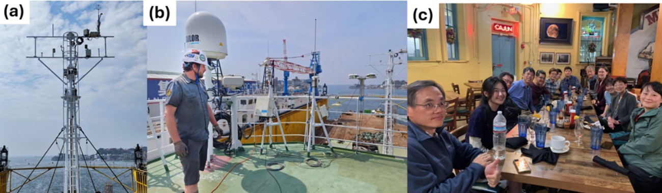
To simulate air–sea interaction processes in coupled models, Reynolds fluxes near the air–sea interface are commonly used as boundary forcings for both the MABL and OSBL. However, because the computation of Reynolds fluxes requires high-frequency meteorological measurements, operational weather forecast models rely on empirical parameterizations derived from past field experiments conducted under calm sea conditions, which may introduce potential biases when these fluxes are applied to extreme sea states characterized by strong wind–wave interactions. Because we have successfully demonstrated that the RVs can be used as reliable platforms for capturing near-surface atmospheric variability around Taiwan, upgrading the existing meteorological sensors can further support the needs of high-frequency sampling in the air-sea interaction processes even under intense sea conditions. Since 2024, a long-term collaboration between IONTU and National Oceanic and Atmospheric Administration (NOAA) has been established through an official MOU. A joint atmosphere–ocean field campaign was successfully conducted in 2025 (Fig. 1a and b) under the support of Dr. Elizabeth Thompson, a principal scientist in NOAA’s Physical Sciences Laboratory (PSL). The same suite of sensors used in the PSL will be purchased and installed on all three research vessels (Figs. 1a and b). The second major goal of this sub-project is to develop a standardized procedure for accurately measuring air–sea fluxes and transmitting these data in near-real time during each research cruise, ensuring consistent data quality, improved model forcing, and enhanced support for coupled modeling efforts.
Beyond the goals for deriving high-quality datasets for AI-based model training, we aim to continuously deepen collaborations with Taiwanese meteorologists to advance the understanding of fine-scale turbulence within the MABL. Over the past two years, several faculties in the physical oceanography division of IONTU have worked closely with Dr. Wei-ting Chen and Dr. Chien-Ming Wu of the Department of Atmospheric Science at National Taiwan University (NTUAS). In this collaboration of joint atmosphere–ocean field campaigns in the western Pacific, the NTUAS team applied their high-resolution Vector-Vorticity Equation Cloud-Resolving Model to examine how SST variability along ship trajectories modulates small-scale turbulent processes and influences subsequent cloud development through the framework of traditional geophysical fluid dynamics. Their simulations reveal that incorporating shipboard underway SST measurements can substantially improve cloud forecasts within a three-day integration, emphasizing the pivotal role of OSBL dynamics in shaping weather system evolution. When combined with the results of air-sea fluxes from this sub-project’s second goal, these findings enable us to further investigate how OSBL structure drives SST variability and, in turn, induces changes in MABL characteristics through modified turbulent fluxes.
Besides, the planned upgrades to the observational capabilities of RVs also create significant opportunities to deepen international partnerships. Over the past several years, our team has actively engaged with the NOAA through another joint international field initiative: the Tropical Pacific Observing System (TPOS) Equatorial Pacific Experiment (TEPEX). This campaign, described in detail on NOAA’s project page, focuses on improving understanding of the coupled atmosphere–ocean processes in the central equatorial Pacific. Since the initial discussions during the Ocean Sciences Meeting 2024 (Fig. 12c), we have held extensive online meetings with key collaborators, including Dr. Chidong Zhang from NOAA and Dr. Shuyi Chen from the University of Washington, to refine the scientific objectives, observational strategies, and logistical requirements of the TEPEX field experiment. Although NOAA experienced funding uncertainties during 2025, our partners have reaffirmed that the field campaign remains highly likely to proceed in the spring 2028. This sustained commitment underscores the scientific importance of the experiment and highlights the value of Taiwan’s contributions to multinational research efforts in the Pacific.
Annual goals
- Year 1 :
-
(a) Purchase and install meteorological sensors that can be used in the direct estimation of air-sea fluxes.
(b) Investigate and collect the surface wave data captured by X-band wave radar at all research vessels.
(c) Coordinate the pilot study of the international field campaign TEPEX with NOAA in 2027. - Year 2 :
-
(a) Integrate the shipboard wind measurements with the existing satellite wind product.
(b) Develop standard procedures for the processing and quality-control of air-sea flux measurements.
(c) Coordinate the official study of the international field campaign TEPEX with NOAA in 2028. - Year 3 :
-
(a) Publish a version of the wind product that has been synthesized with the shipboard measurements.
(b) Release the product of shipboard air-sea flux measurements for domestic analysis.
(c) Investigate the influence of shipboard meteorological products on the forecast of finescale dynamics in the marine atmospheric boundary layer.
(d) Conduct the field experiment for the air-sea interaction research in western Pacific. - Year 4 :
-
(a) Publish product of shipboard surface wave data that can be used for the air-sea interaction study.
(b) Integrate air-sea flux measurements into the prediction of atmospheric or oceanic dynamics.
(c) Explore the possibility of publishing shipboard data in near-real time.