Chief Scientist
Yu-Chieng Liou
Abstract
This four-year project aims to conduct continuous and direct observations of the marine atmospheric boundary layer (ABL) in the vicinity waters of Taiwan so that its characteristics can be studied in detail. The major instrument used for atmospheric observations in this project is a state-of-the-art shipborne C-band dual-polarimetric Doppler weather radar on board R/V New Ocean Researcher 1 (NOR1). The other instruments include storm tracker/radiosonde, Micro Rain Radar (MRR), Doppler Wind Lidar (DWL), radiometer, and GNSS_ZTD receiver. In addition, synchronized observations of the ocean surface boundary layer (OSBL) would also be conducted to explore how the near-surface stratified layers interact with the weather systems in the marine ABL.
With the high spatiotemporal resolution data sets collected by a wide spectrum of advanced observational instruments,
the scientific goals of this project would cover the following topics:
(a) Understand the dynamic, thermodynamic, and microphysical structure and time-space characteristics (including diurnal cycle) of the marine ABL,
with a focus on the marine boundary layer jet (MBLJ) in the South China Sea and barrier jet (BJ) in Taiwan Strait, which are important triggering mechanisms for heavy rainfall in Taiwan;
(b) Study the air-sea interaction leading to the development of marine LLJs;
(c) Provide high-quality data sets to verify the accuracy of the representations of marine ABL and MBLJ/BJ by numerical models and reanalysis data;
(d) Provide independent inter-comparisons to validate the satellites measurements over oceans such as those by TASA’s GPSRO and GNSS-R/TRITON, and the GNSS_ZTD retrieved moisture;
(e) Provide critical local data sets for training artificial intelligence systems. This project will be the first of its kind in Taiwan in terms of using a complete set of in-situ and remote sensing instruments to conduct joint atmospheric and oceanic sciences field experiments.

Science questions
The Low-Level-Jets (LLJs) are areas with very strong wind speeds occurring in the atmospheric boundary layer (ABL). Marine LLJs in the vicinity waters of Taiwan have been identified as an important factor triggering the heavy and hazardous rainfall in Taiwan. Thus, it is important to understand the characteristics of marine LLJs and improve the forecast of their occurrence.
Most previous research on marine LLJs relied on low temporal and/or spatial resolution data sets (e.g. synoptic weather maps, reanalysis data, surface station, radiosonde). Numerical models and satellites are useful, but the representation of the marine LLJs and ABL in their outputs requires detailed verification by other independent observations. Using shipborne instruments to detect the marine ABL and LLJs has been conducted by scientists for many years, but in most cases, these instruments include only radiosonde or lidar (usually only vertical pointing)
Approach
We propose to conduct observations near or directly within the marine ABL in the vicinity waters of Taiwan. A complete set of instruments is prepared to conduct high spatiotemporal resolution atmospheric observations under all weather conditions in a seamless mode. These instruments include the first-ever shipborne dual-polarimetric Doppler weather radar on board R/V NOR1, storm tracker/radiosonde, Micro Rain Radar (MRR), Doppler Wind Lidar (DWL), radiometer, and GNSS_ZTD receiver.
Scientific goals and application
- (a)
- Understand the dynamic, thermodynamic, and microphysical structure and time-space characteristics (including diurnal cycle) of the MABL, with a focus on the marine boundary layer jet (MBLJ) in the South China Sea and barrier jet (BJ) in Taiwan Strait.
- (b)
- Study the air-sea interaction processes leading to the development of marine LLJs.
- (c)
- Provide high-quality data to verify the accuracy of the representations of MABL and MBLJ/BJ by numerical model simulations and reanalysis data sets.
- (d)
- Provide independent inter-comparisons to validate the measurements or derived-products by satellites over oceans such as TASA’s GPSRO, GNSS-R/TRITON, the GNSS_ZTD retrieved moisture.
- (e)
- Provide critical local data sets for training artificial intelligence systems.
Uniqueness
This project will be the first of its kind in Taiwan in terms of using shipborne in-situ and remote sensing instruments to conduct joint atmospheric and oceanic sciences field experiments. The strategy we proposed to obtain high-quality data sets for the study of marine ABL, LLJs, and aerosols would be irreplaceable by any other observational means.
Low-level jets
The heavy rainfall (> 100 mm/day) in Taiwan during the early summer rainy season (May to June) is highly influenced by the Mei-Yu front and is frequently related to the low-level jet (LLJ). LLJs can be classified into three different categories (Chen et al. 2022). They are (i) a synoptic low-level jet (SLLJ) located in the 850–700 hPa layer in the frontal zone; (ii) a marine boundary layer jet (MBLJ) embedded within the prevailing southwesterly monsoon flow at approximately the 925 hPa level over the northern South China Sea; (iii) a terrain-induced barrier jet (BJ) at about 1.0 km height off the northwestern coast of Taiwan with the wind direction nearly parallel to the coastal terrain.
The definition of the LLJ could vary among different researchers. For example, Chen and Yu (1988) utilized a minimum horizontal wind speed of 12.5 m s−1 at the 850 hPa level and 15 m s−1 at the 700 hPa level to define the LLJs. In Du et al. (2014), the vertical variation of the wind speed is also considered an additional criterion. Their definition of an LLJ is when a wind speed maximum exceeding 10 m s−1 occurs in the lowest 4 km and a decrease with height by more than 3 m s−1 above the level with the maximum wind speed.
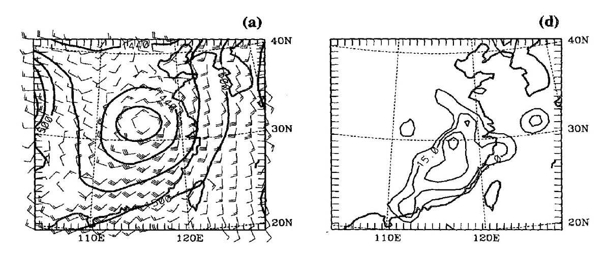
For SLLJ, the analyses of data from the 1987 Taiwan Area Mesoscale Experiment (TAMEX) revealed that it began with an initial vortex forming on the lee side of the Tibetan Plateau. This vortex developed into a Mei-Yu frontal cyclone with the SLLJ located in the warm sector of the front. The cause of the SLLJ is a response to the moist baroclinic forcing as the frontal system deepens. The further intensification of the SLLJ is induced by the cross-isobaric flow towards the low-pressure center of the deepening frontal cyclone. Fig. 1 provides an example obtained in IOP 5 during TAMEX. It can be seen from Fig. 1a that a cyclone center was identified at 32° N, 115° E at 850 hpa, and the SLLJ became well-defined with a maximum wind speed exceeding 20 m s−1 over the land at 850 hpa, as shown in Fig. 1b.
The MBLJ usually occurs after June 1st, which is the second half of the monsoon season in Taiwan, and is associated with the deepening of the Mei-Yu trough over southeastern China and the strengthening and/or westward extension of the west Pacific subtropical high. The abundant moisture transported by the MBLJ from the northern South China Sea provides a favorable condition for the heavy rainfall in Taiwan.
The BJ is most evident when a windward-ridge/lee-side-trough pressure pattern forms over Taiwan under the presence of both SLLJ and MBLJ. The upstream flow is first decelerated due to an orographically induced pressure in southwestern Taiwan and then splits off the southwestern coast. The northern part of the deflected flow is accelerated downstream by the pressure gradient force along the western coast of Taiwan, leading to a BJ over the northwestern Taiwan coast.
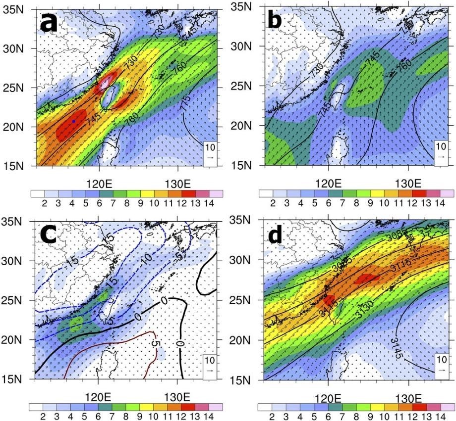
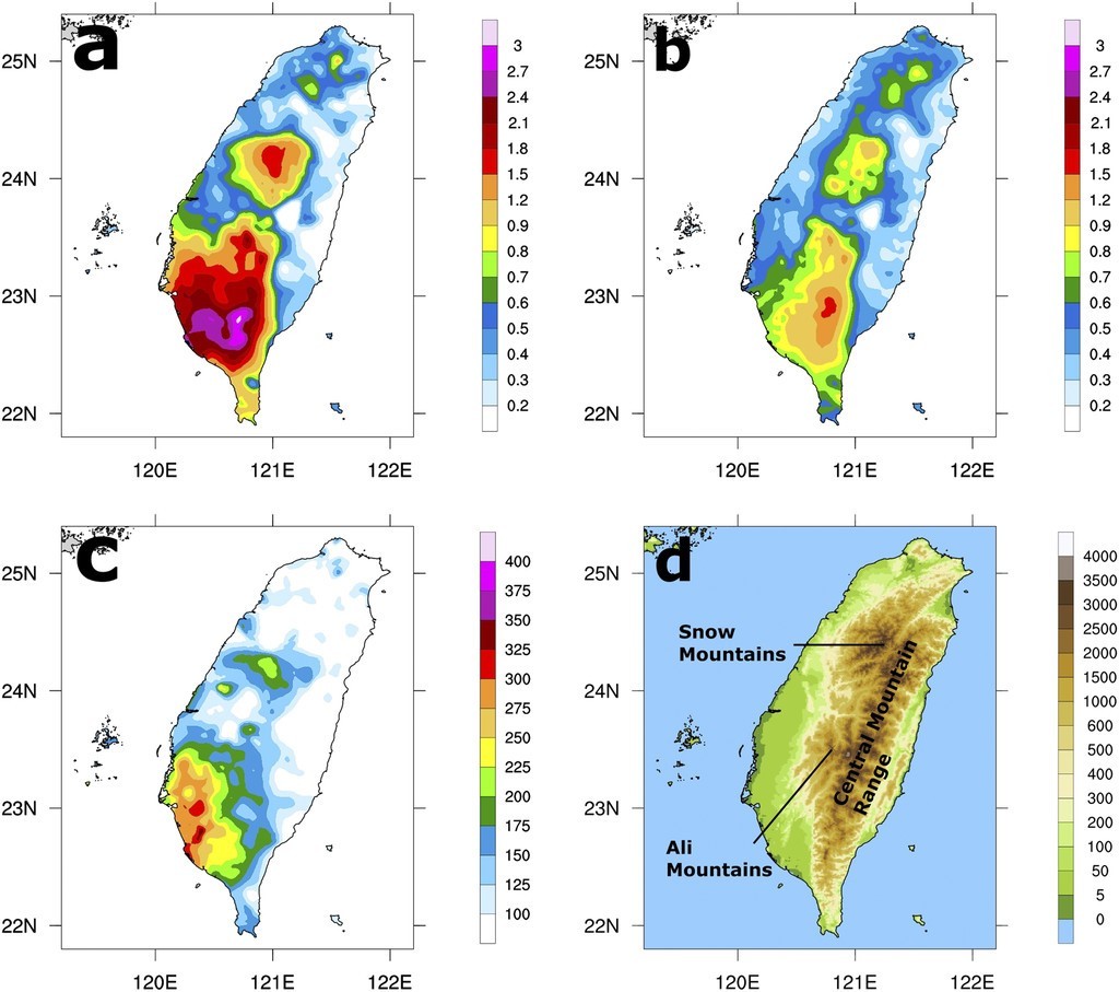
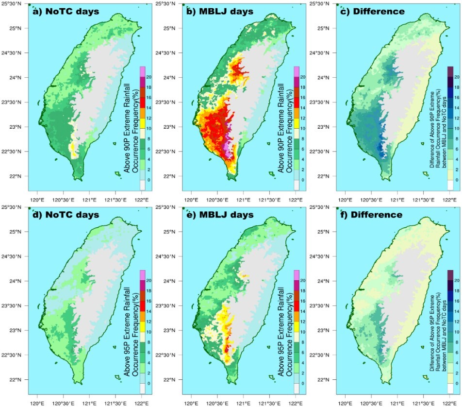
Fig. 2 is an example of MBLJ and BJ from Tu et al. (2019). By using National Centers for Environmental Prediction (NCEP) Climate Forecast System Reanalysis (CFSR) data from 2008 to 2012, they defined the existence of a southwesterly MBLJ over the northern South China Sea by the following two criteria: (i) maximum wind speed is greater than 10 m s−1 below the 900-hPa level; and (ii) between the height of the maximum wind to the wind minimum aloft, the wind speed below 4 km decreases by at least 3 m s−1. Furthermore, an MBLJ day is defined if more than 60% of the grid points in an upstream box (116-120°E, 19-22°N) satisfy the MBLJ criteria for more than 6 hr. Fig. 2a illustrates that during MBLJ days the strong southwesterly monsoon flow with wind speed greater than 10 m s−1 covered a large portion of the northern South China Sea. The core of the jet was located upstream of southwestern Taiwan. The Mei-Yu trough over southern China and the West Pacific subtropical high (WPSH) were located to the northwest and southeast of the jet core, respectively. Fig.2b showed that the June monthly mean winds at 925 hpa upstream of Taiwan did not exceed the low-level jet criteria. However, the difference between the MBLJ days and the June monthly mean did reveal that MBLJ was associated with a deeper Mei-Yu trough and a stronger WPSH. Fig. 2a also depicted the presence of a BJ off the northwestern coast of Taiwan, which was the result of orographic blocking leading to the enhancement of the MBLJ. Fig. 3a revealed that during the MBLJ days, the southwestern slopes of Ali Mountains and Snow Mountains and the southwestern coastal plain receive 150%–250% and 250% of rainfall, respectively, as compared to the June monthly mean value (Fig. 3b). This is caused by the orographic blocking of MBLJ (Tu et al. 2019). Also by utilizing rain gauge data measured in June over 20-yr (1999~2018), selecting 438 days when the influence of tropical cyclones was not obvious (NoTC days), and using the 90th percentile as the threshold to determine the extreme rainfall (approximately 69 mm day−1 in this case), Fig. 4 revealed that the frequency of the occurrence of extreme rainfall was significantly higher in MBLJ days than that for June climatology of all NoTC days. Note that here MBLJ day was defined when the jet core with wind speed reaching 10 ms−1 occurred below 900 hpa in Dongsa island, and a total of 165 days were identified. Figs. 3 and 4 are clear indications of the connection between MBLJ and the heavy rainfall in Taiwan.
The role played by LLJs has been noticed and the studies of this topic have a long history in Taiwan. For example, Chen and Chang (1980) mentioned the finding of a LLJ in a field experiment held in Japan. Chen (1983) documented from an observational perspective the climatology of Mei-Yu front and its associated LLJ over southern China and Taiwan for 1968-1977. By analyzing synoptic weather charts and data sets collected by surface stations and radiosondes, Chen and Yu (1988) reported that statistically there was an 84% likelihood that a LLJ (> 12.5 ms-1) would be present at 700 hpa 12 hr before the start of the rainfall event. On the other hand, when a LLJ existed over Taiwan, there was a 91% probability that a rainfall event would be in its developing stage and begin on the next day. Their study also suggested that the LLJ is the cause of the convection in Taiwan instead of the result of the momentum transport in the convective system. Chen et al. (1994) conducted a diagnostic study of the low-level jet during TAMEX IOP5, and identified a secondary circulation associated with the jet/front system. Chen et al. (2005) documented the relationship between the onset of heavy precipitation with the frequency, vertical structure, and spatial/temporal distribution of LLJ. Their findings showed that the starting points of many of these LLJ streaks were mostly over the South China Sea or surrounding coastal regions, and some were near the Taiwan Strait. Chen et al. (2018) found that during a widespread heavy rainfall event, the maximum low-level horizontal moisture flux from the northern South China Sea to Taiwan associated with the southwesterly monsoon flow could reach more than 330 g kg−1 m s−1. They attributed this feature to the existence of the MBLJ (Tu et al. 2019).
Motivation
The aforementioned description in the previous section clearly indicates the important role played by the MABL and the close relationship between the LLJs and the heavy precipitation in Taiwan. Consequently, a better understanding of the detailed characteristics (including dimension and intensity) and evolution of the LLJs as well as the very localized small-scale convective systems (Ke et al. 2019) triggered by LLJs would be extremely helpful in terms of improving the forecasts of heavy rainfall. This purpose can be achieved by analyzing the observational data collected from advanced instruments deployed directly within the MABL.
It should be pointed out that many of the previous studies of MABL and LLJs usually relied on synoptic weather charts, reanalysis data from operational centers such as NCEP or European Centre for Medium-Range Weather Forecasts (ECMWF), and/or data from surface stations and radiosondes. These data sets are low in spatial and/or temporal resolutions. For example, the data sets used by Tu et al. (2020) to investigate the favorable conditions for MBLJ and moisture transport in the marine boundary layer were NCEP CFSR data (Saha et al. 2010) with a 0.5o x 0.5 o grid resolution at 6-hr intervals. Tu et al. (2020) also compared the radiosonde data released at Dongsha Island and the fifth Generation ECMWF atmospheric reanalysis datasets (ERA5), and found that the latter could underestimate the horizontal moisture flux by as many as 30 g kg−1 m s−1, as shown by Fig. 5. Very recently Zhang et al. (2024) examined the vertical structures and temporal evolution of MBLJs in the northern South China Sea from 15-18 June 2022 through direct balloon radiosonde observations and evaluated the performance of various reanalysis datasets in representing these MBLJs. Their study revealed that in ERA5 the moisture was generally underestimated within the boundary layer and overestimated at mid-levels around 800 hpa. The ERA5 also has difficulty accurately capturing the diurnal peaks in wind speeds. It is worth mentioning that in ERA5, 37 pressure levels are utilized to cover a vertical range of 1000 hpa, which makes the vertical resolution of the ERA5 datasets ranging approximately from 25 to 50 hpa. In contrast, the vertical resolution of a balloon radiosonde below 650 hpa could reach as high as 1.0 hpa (Tu et al. 2020). This comparison clearly indicates the necessity to conduct direct observation by using shipborne instruments in order to resolve the detailed structure of the MABL.
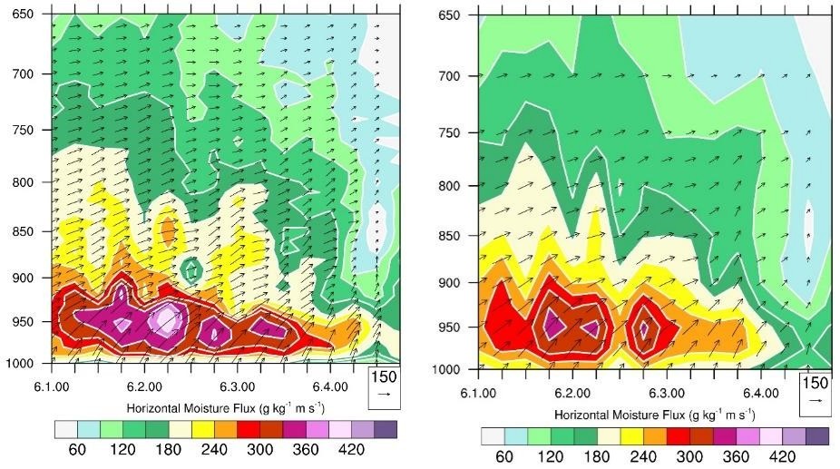
Numerical models are also powerful tools for studying the MABL and LLJs (Chen et al. 1997, Du et al. 2014, Chen et al. 2018). Lin et al. (2023) conducted numerical sensitivity experiments and found that varying sea surface temperature (SST) over the South China Sea could modify the structure of MBLJ and thus affect the rainfall in Taiwan. However, comprehensive verifications of the model outputs are necessary to assure the accuracy of the simulations.
Winning et al. (2017) utilized the GPS radio occultation to estimate the MABL height over the central North Pacific and demonstrated that remote sensing data could also play an important role in boundary layer and LLJs research. Similarly, verifications of the satellite-derived results over the ocean are important and yet difficult. Ke et al. (2019) utilized multiple-Doppler-radar wind retrievals to analyze a BJ off the northwestern coast of Taiwan. Their analyses barely touched the height of 1.0 km, which was roughly the depth of the BJ. This was because the radar systems used in their study were all ground-based, which were not able to scan MABL from the land due to the earth’s curvature. Liu (2021) analyzed the data from a 499 MHz wind profiler located on Dongsa Island to study the characteristics of the LLJ during the Mei-Yu season (5/16~6/15) from 2018 to 2020, including the frequency, vertical variation of the wind direction and intensity, and the diurnal cycle. Mechanisms causing these features were also discussed. However, this study was based on observations at a fixed single point on a small island.
Using shipborne instruments to observe the MABL and/or LLJs has been performed by scientists for many years. For example, Wulfmeyer and Janjic (2005) explored the structure of the MABL in the tropical Pacific Ocean using instruments on board two research vessels (Mirai and Ronald H. Brown) and on Nauru Island. Tanimoto et al. (2009) made an observational study of the MABL transitions across the summer Kuroshio extension using data collected by R/V Roger Revelle. The annual characterization of LLJs over the Arctic Ocean was presented in López-Garciá et al. (2022) by analyzing the measurements conducted on board the icebreaker Polarstern. However, among these studies, their atmospheric data sets were mostly collected by radiosonde, lidar, or ceilometer. Weather radars, especially those with three-dimensional scanning capability, were rarely available.
Based on the reasons listed above, the goal of this four-year project is to conduct direct and continuous observation of the MABL in the vicinity waters of Taiwan so that its characteristics can be investigated in great detail. The major instrument used for atmospheric observations in this project is the first-ever shipborne dual-polarimetric Doppler weather radar in Taiwan on board NOR1. The other instruments include storm tracker/radiosonde, Micro Rain Radar (MRR), radiometer, Doppler wind lidar and GNSS_ZTD receiver. With the high spatiotemporal resolution data sets, the scientific goals of this project would cover the following topics:
- (a)
- Understand the dynamic, thermodynamic, and microphysical structure and time-space characteristics (including diurnal cycle) of the MABL, with a focus on the marine boundary layer jet (MBLJ) in the South China Sea and barrier jet (BJ) in Taiwan Strait.
- (b)
- Study the air-sea interaction processes leading to the development of marine LLJs.
- (c)
- Provide high-quality data to verify the accuracy of the representations of MABL and MBLJ/BJ by numerical model simulations and reanalysis data sets.
- (d)
- Provide independent inter-comparisons to validate the measurements or derived-products by satellites over oceans such as TASA’s GPSRO, GNSS-R/TRITON, the GNSS_ZTD retrieved moisture.
- (e)
- Provide critical local data sets for training artificial intelligence systems.
Proposed deployments of R/V NOR1 and time slots for the observations of marine LLJs
A working group meeting was held at the National Science and Technology Council (NSTC) on March 13, 2024. In that meeting, a conclusion was reached that a 10-day schedule would be reserved every year specifically for the joint atmosphere-ocean observations. Under this condition, considering the time needed to reach the targeted area, it is proposed in this project to conduct joint observations in the vicinity waters of Taiwan.
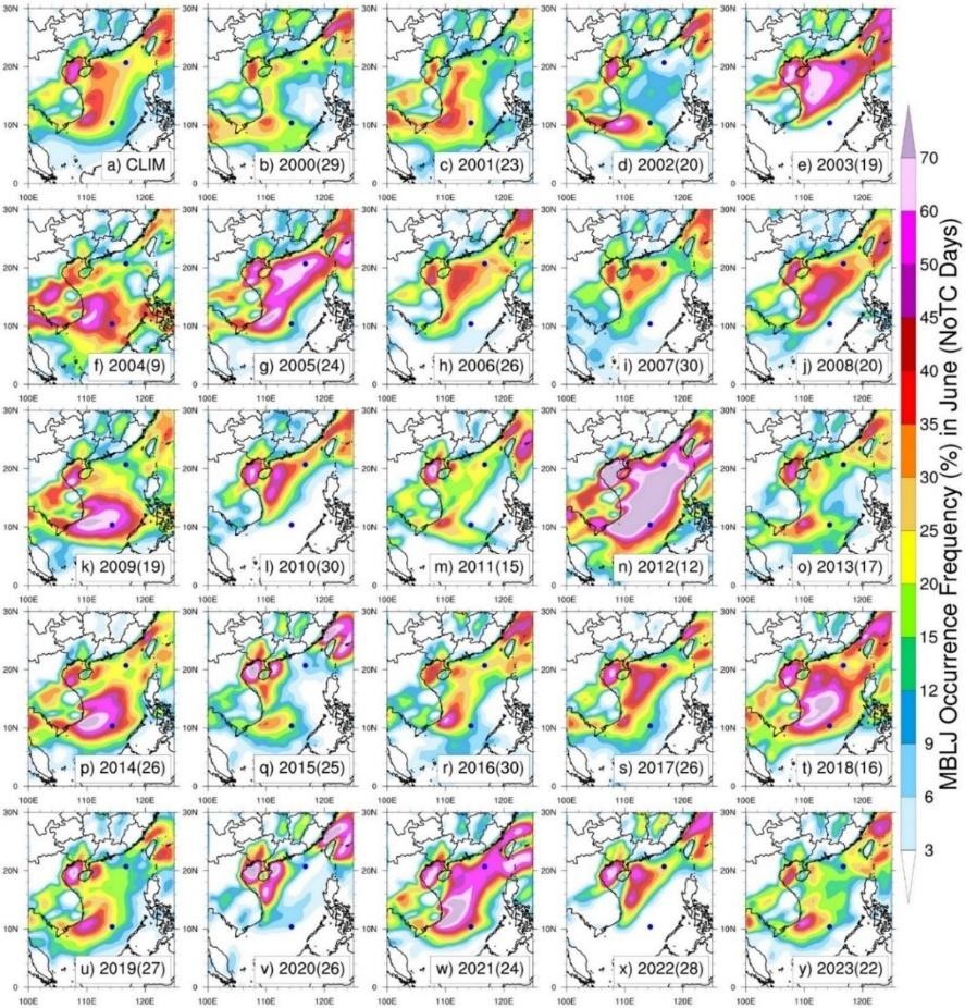
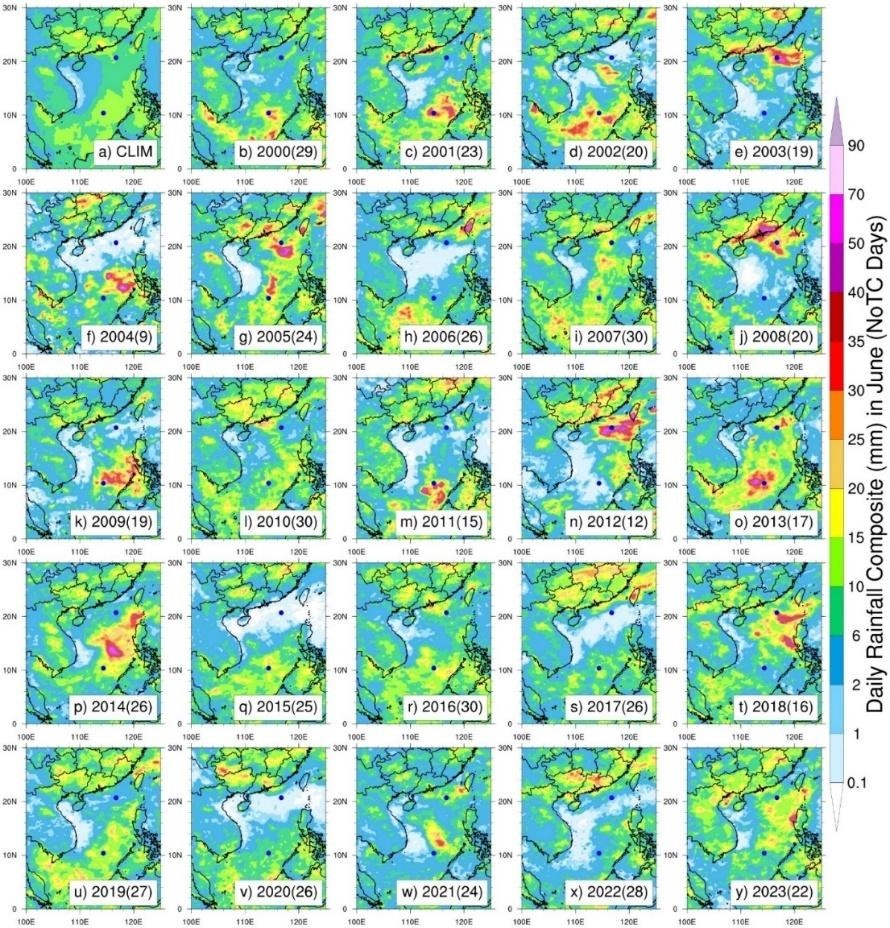
Statistically in Taiwan, LLJs are prone to occur in the early summer season. By using the definition of MBLJ days previously explained, the occurrence frequency of MBLJ is determined by computing the ratio between the number of MBLJ days and the total number of days without the influence of tropic cyclones (NoTC Days). Fig. 6 illustrates the occurrence frequency of MBLJ in June from 2000 to 2023. It can be seen that the interannual variation of frequency is evident. However, from the climatological perspective, the frequency near Dongsha Island can reach around 25-30%, while the frequency in the northern part of the Taiwan Strait exceeds 40%. Note that this is also the area where the BJ frequently occurs, although its definition (> 15 ms−1, see Ke et al. 2019) is somewhat different from MBLJ. Fig. 7 is similar to Fig. 6, but is the daily accumulated rainfall. A simple estimation shows that a 10 mm accumulated rainfall per day is equivalent to approximately 20 dBZ of radar reflectivity. From Fig. 6a, it can be seen that climatologically a reasonable amount of rainwater detectable by a radar would take place in the Dongsha Island area and Taiwan Strait.
Based on the discussion above, it is proposed to deploy R/V NOR1 near Dongsha Island and the northern part of Taiwan Strait in June in different years to observe the LLJs in the ABL. The observational plan includes the use of the storm tracker/radiosonde to observe MABL under all weather conditions. During clear sky and light rain conditions, the radiometer, Doppler wind lidar, and MRR can be applied to observe the vertical structure of the MABL. During rainy conditions, the shipborne weather radar with a detection range reaching 150 km would be operated to provide high spatiotemporal resolution three-dimensional scans of the convective systems in the MABL. Special scanning strategies such as multiple RHI scans can be designed specifically for the observations of marine LLJs. Lin et al. (2023) reported the modification of MBLJ by the variation of sea surface temperature. Their study implies the importance of air-sea interaction and the necessity of joint atmospheric and oceanic observations. Thus, synchronized oceanic observations would also be conducted to explore the air-sea interaction leading to the development of marine LLJs.
Annual goals
- Year 1 :
- (2026-2027) (a) Develop necessary data process algorithms and practice data analyses using data collected by shipborne instruments. (b) Facilitate the participants of this project to accumulate experience in conducting joint R/V NOR1 atmospheric and oceanic observations in the vicinity of Dongsha Island.
- Year 2 :
- (2027-2028) (a) Analyze the data observed by shipborne instruments on board R/V NOR1 in the first year. (b) Continue the R/V NOR1 observation in the vicinity of Dongsha Island for the second year to observe any variations in marine ABL characteristics from the previous year.
- Year 3 :
- (2028-2029) (a) Continue to analyze the data observed by shipborne instruments on board NOR#1 in the previous two years. (b) Conduct R/V NOR1 observation in the northern part of the Taiwan Strait with the barrier jet as the focus.
- Year 4 :
- (2029-2030) (a) Continue to analyze the data from shipborne instruments on board NOR1 in the previous three years. (b) Conduct R/V NOR1 observation in the northern part of the Taiwan Strait for the second year to observe any variations in marine ABL characteristics from the previous year.