Chief Scientist
Yu-Hsin Cheng
Under a changing climate, the frequency and intensity of extreme weather and marine anomalies—such as marine heatwaves and marine cold spells (Schlegel et al., 2021)—are increasing. This subproject sits at the core data-to-application component of TOPMOON-II and is designed to bridge high-resolution satellite remote sensing with Taiwan’s in-situ observing network. We will develop and deploy free-drifting observing platforms, with a particular emphasis on Wirewalker-type systems (Fig. 1), to obtain high-resolution hydrographic and upper-ocean thermal structure measurements along the Kuroshio pathway east of Taiwan. By integrating these in-situ observations with artificial intelligence (AI) methods, we will address the well-known discrepancy between satellite-derived skin sea surface temperature (skin SST) and physically meaningful bulk sea surface temperature (bulk SST). In parallel, we will develop AI-based detection of Kuroshio axis variability and establish an early-warning framework for marine cold events. The ultimate outcome will be a scientifically robust and operationally relevant AI-ready database that provides a solid foundation for environmental prediction and decision support in the waters surrounding Taiwan.
The subproject is structured as an end-to-end workflow with four integrated objectives. First, drifting platforms (Wirewalker and SAFE-2; see Fig. 2 and AUV's Fig. 2, respectively) will quantify hydrographic variability and upper-ocean thermal evolution along the Kuroshio, providing the validation backbone for satellite SST and surface current products. Process-oriented analyses will link mesoscale–submesoscale dynamics to upper-ocean mixing and heat redistribution, enabling a physically interpretable pathway from “ocean processes” to “satellite biases” and, ultimately, to correction strategies. Second, Kuroshio path variability will be monitored by combining conventional satellite altimetry with high-resolution observations from SWOT, which measures surface height over the global ocean and terrestrial waters (rivers, lakes, and reservoirs). We will develop AI methods to detect the Kuroshio axis and quantify path variability, producing daily axis positions and indices with uncertainty-aware confidence metrics. These products will be cross-validated using TOPMOON buoy measurements and drifting profiles to ensure consistency with observed changes in the Kuroshio. Third, to address skin-to-bulk SST discrepancies, we will build a matchup database focused on the diurnal warm layer by integrating AHI high-temporal-resolution SST with high-frequency vertical profiles from Wirewalkers and moored buoys. AI-based inversion models will then reconstruct skin SST into bulk SST representative of the upper mixed layer, improving suitability for coupled models, data assimilation, and event monitoring. Fourth, we will operationalize an anomaly detection and warning system based on historical climatologies and real-time departures, integrating bulk SST, satellite-derived currents, Kuroshio axis metrics, and key station time series (e.g., the Matsu buoy). Using the Penghu Islands as a demonstration region, we will conduct event-backtracking analyses to connect rapid cooling episodes to circulation changes, including channel-flow dynamics and water-mass intrusion pathways, and deliver an operational warning “signal-level” product for real-time awareness and post-event attribution.

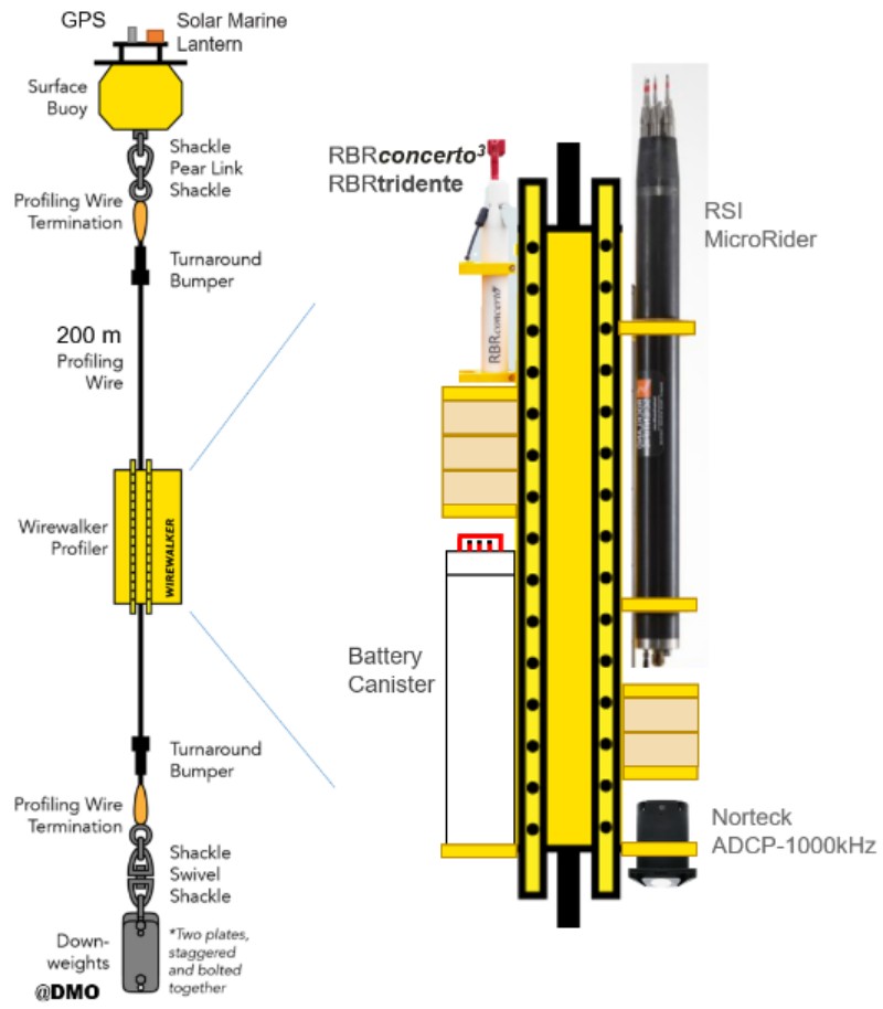
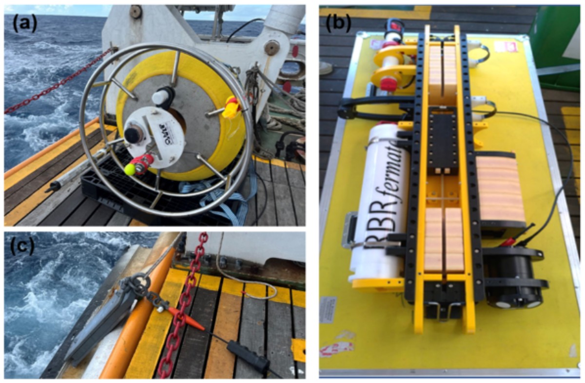
Methodologically, the project starts from the principle that satellite products must be anchored by in-situ observations, and it maintains an AI-ready data engineering pipeline from raw measurements to operational products to ensure usability, traceability, and reproducibility. For the drifting observational component, we will design missions spanning the main Kuroshio path and upstream regions toward eastern Taiwan, deploying Wirewalkers and/or SAFE-2 to capture upper-ocean thermal structure, mixed-layer depth variability, and high-frequency signals associated with diurnal warming. Where feasible, velocity measurements or shear-related diagnostics will complement these deployments to compensate for satellite limitations under cloud cover, in coastal proximity, or under specific atmospheric conditions. All in-situ measurements will be rigorously matched in space and time with satellite products through a standardized matchup procedure, including automated cloud screening and clearly defined matchup windows. Satellite errors will be quantified using bias, RMSE, and stratified diagnostics across relevant regimes—such as season, day versus night, wind–wave conditions, and Kuroshio position states—producing validation results that directly inform satellite algorithm refinement and AI model feature design.
Annual goals
- Year 1 :
- Conduct pilot Wirewalker/SAFE-2 deployments; deliver baseline satellite SST/current validation, a prototype daily Kuroshio axis product, and preliminary anomaly monitoring for Penghu.
- Year 2 :
- Expand multi-season drifting observations and matchup datasets; establish the AI-ready pipeline and standards for Kuroshio axis detection using altimetry; initial skin-to-bulk SST mapping; analysis of the physical processes and mechanisms of marine cold-spell warning.
- Year 3 :
- Expand multi-season drifting observations and matchup datasets. Release routine bulk SST with uncertainty. Upgrade AI for Kuroshio axis detection (plus SWOT when available); Fuse conventional altimetry, SWOT high-resolution surface height, and in situ data into a coherent operational suite; calibrate marine cold-spell warning thresholds and confidence flags.
- Year 4 :
- Consolidate stable operations and long-term indicators; finalize validated datasets, documentation, and versioning; deliver operational-ready Kuroshio axis, bulk SST, and anomaly warning signal products on the TOPMOON platform for cross-agency adoption.