Chief Scientist
Ming-Huei Chang
Je-Yuan Hsu
Under climate change, sea surface temperature warming patterns are shaped not only by radiative and atmospheric forcing, but also by regional ocean heat transport and cross-scale horizontal and vertical exchange processes. The local temperature tendency reflects the balance among air–sea heat flux, horizontal advection by multi-scale currents, and vertical redistribution through upwelling, turbulent mixing and stratification. Consequently, regions with heat convergence and enhanced stratification exhibit amplified surface warming, whereas areas with strong upwelling or vertical mixing may experience moderated or even weak surface warming despite the same large-scale forcing. This imbalance between heat input and vertical redistribution can amplify local thermal anomalies, increasing the frequency and intensity of marine heatwaves (MHWs). Taiwan is situated in one of the most dynamically energetic regions of the global ocean, where the Kuroshio (the western boundary current in the northern Pacific), topographically generated internal tides, mesoscale eddies, and recurrent typhoons interact across multiple scales. While the Kuroshio and eddies redistribute heat laterally, internal tides and typhoon-induced turbulence enhance vertical mixing, jointly regulating stratification, heat storage, and the development of marine heatwaves. Understanding these coupled processes requires the development of dedicated observational strategies and the integration of artificial intelligence (AI) techniques for improved diagnostics and prediction. The scientific goals of this sub-project are:
- (1)
- To quantify the long-term trends in sea surface temperature (SST), sea surface height (SSH), and turbulent mixing around Taiwan.
- (2)
- To elucidate the roles of background oceanic processes, including the Kuroshio, internal tides, mesoscale eddies, and typhoons, in shaping regional long-term variability.
- (3)
- To investigate upper-ocean responses to air–sea interactions, with emphasis on heat exchange and stratification changes.
- (4)
- To identify the physical mechanisms driving marine heatwaves in the western Pacific near Taiwan.

Methods
To quantify the long-term trends around Taiwan
We will integrate SST and SSH data from satellite remote sensing, numerical modeling, and in situ observations. Satellite products include datasets from the Copernicus Marine Environment Monitoring Service (CMEMS) and NOAA OISST. In situ observations comprise buoy and wave station measurements maintained by the Central Weather Administration (CWA), as well as buoy data from the TOPMOON program. In addition, outputs from the Ocean General Circulation Model for the Earth Simulator (OFES) developed by JAMSTEC (Sasaki et al., 2020) will be analyzed to provide dynamically consistent long-term variability. The revised linear regression method proposed in Chang et al. (2024) will be employed to quantify long-term trends, as it more robustly accounts for and removes seasonal variability, thereby reducing potential bias in trend estimation.
To elucidate the roles of background oceanic processes
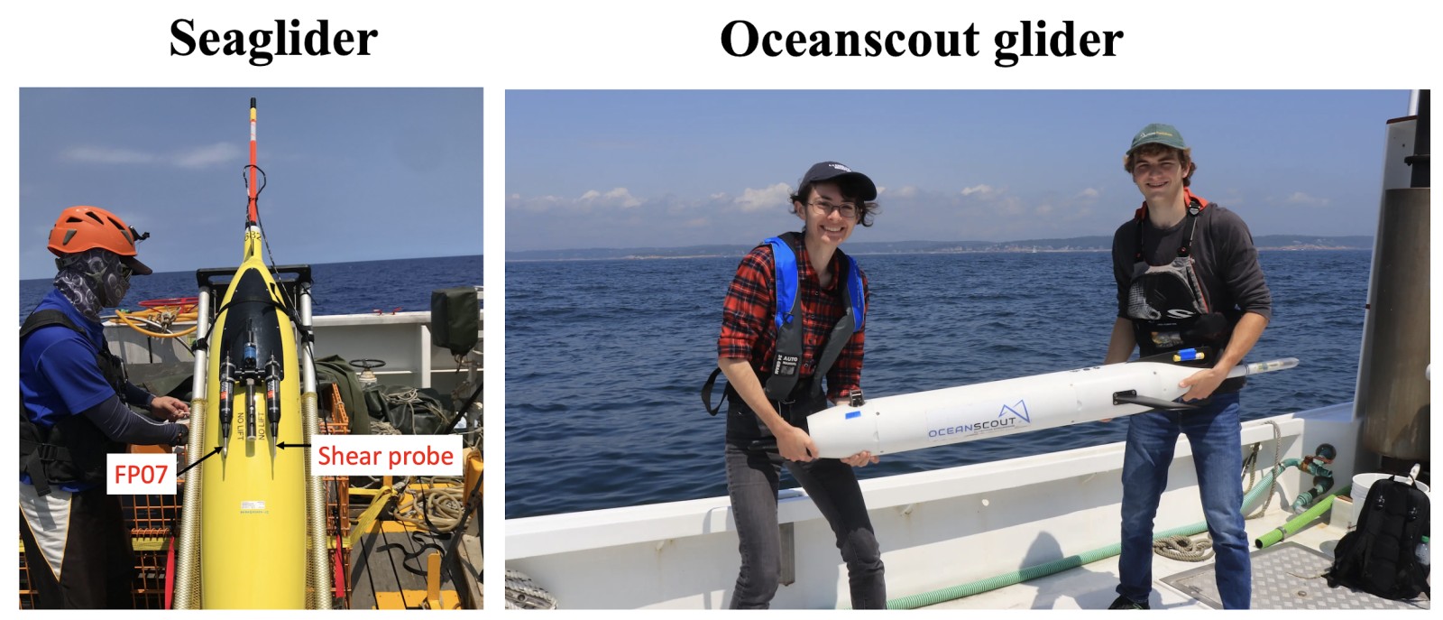
We will collaborate with the integrated NSTC project Multiscale Ocean and Atmosphere Dynamics in the Northwest Pacific and Asian Marginal Seas (MOANA) to share ship time and conduct coordinated field experiments. In addition to conventional ship-based observations of currents, hydrography, and turbulence, we will conduct regular Seaglider deployments. Seagliders are autonomous underwater vehicles designed for long-duration ocean observations. They repeatedly profile from the surface to depths of up to 1000 m, providing high-resolution measurements of temperature, salinity, and other biogeochemical variables. When equipped with turbulence sensors (FP07 thermistor and shear probe; see Fig. 1, left), the gliders offer valuable insights into upper-ocean mixing processes and stratification variability. Their endurance and adaptive sampling capabilities make them particularly suitable for monitoring multiscale ocean dynamics and extreme events such as marine heatwaves and typhoon-induced mixing. We will incorporate newly acquired Oceanscout gliders (see Fig. 1, right) to enhance observational flexibility and rapid-response capability. These compact, cost-effective platforms are particularly suited for typhoon-season deployments and shallow shelf operations, enabling efficient sampling over continental shelves and near-slope regions where strong mixing and topographic interactions occur. Together with Seagliders, they will support sustained monitoring, targeted process studies, and rapid-response missions in dynamically energetic waters around Taiwan.
To investigate upper-ocean responses to air–sea interactions
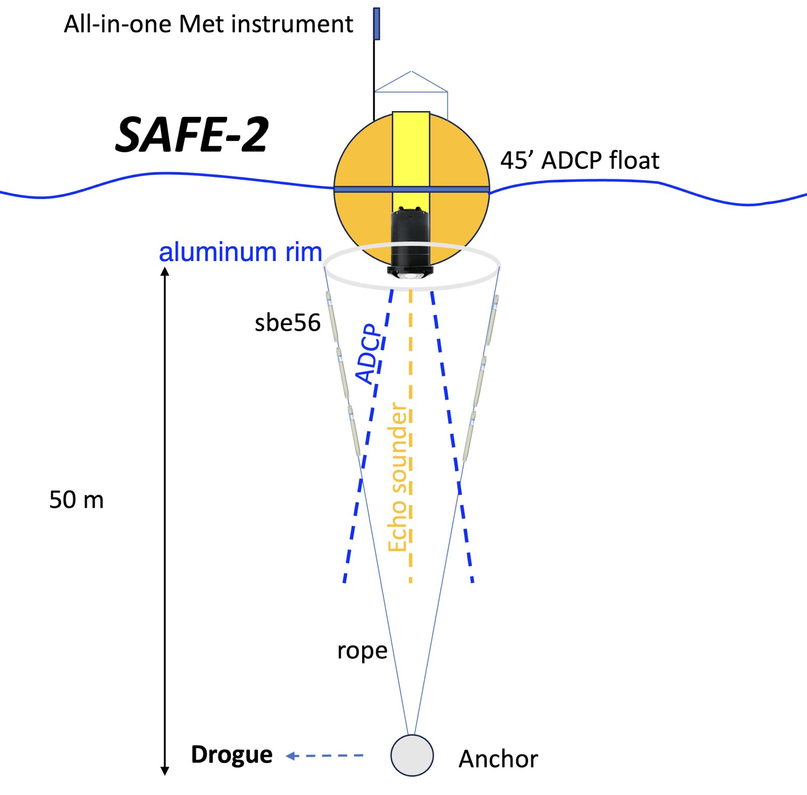
We will further develop the second-generation Sea-Air Floating Explorer (SAFE; Chang et al., 2023) – SAFE-2. SAFE is a customized, freely drifting platform designed to observe surface ocean–atmosphere exchanges. It was developed during the first phase of the TOPMOON project and has successfully captured key physical processes associated with air–sea interactions (see Chang et al., 2023; Hsu et al., 2026). The main upgrades of SAFE-2 include (Fig. 2):
By synthesizing the outcomes of Goals (1)–(3), we aim to establish a process-based framework for marine heatwaves in the western Pacific near Taiwan. This framework will refine heatwave detection indices, characterize event evolution, and elucidate their dynamical links to air–sea exchange, background circulation, and long-term climate change. To improve the detection of marine heatwaves and long-term trends around Taiwan, we will combine physics-based methods with AI approaches. Long-term SST/SSH trends will first be quantified using advanced regression techniques (Chang et al., 2024) to remove seasonal variability. Machine learning models will then be applied to identify nonlinear trends and regime shifts beyond linear warming signals. For MHW detection, the percentile-based threshold method will provide a baseline definition, while convolutional neural networks (CNNs; e.g., Reichstein et al., 2019) will be used to recognize spatially coherent warming patterns in daily SST fields. Explainable AI tools will further assess the relative contributions of air–sea fluxes, circulation variability, and vertical mixing, enabling a process-based understanding of extreme warming events under ongoing climate change.
EM-APEX float observation
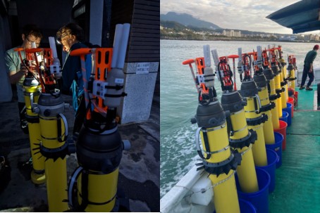
EM-APEX floats (Fig. 3) are autonomous underwater vehicles specifically engineered to obtain high-resolution measurements of oceanic currents and surface water properties. Each float is equipped with two pairs of orthogonal electrodes (E1 and E2) and a magnetometer, often referred to as EM sensors that can record voltage and magnetic field variations at a sampling rate of 1 Hz. A CTD sensor mounted at the top of the float provides concurrent temperature and salinity measurements. The float’s buoyancy is actively controlled through an internal oil-driven engine, allowing it to execute continuous vertical profiles through the water column. During ascent or descent, a slanted blade array is driven by the relative vertical flow of seawater, inducing rotation of the EM sensors. This mechanism links the rotation rate directly to the float’s vertical speed (~0.15 m s⁻¹), thereby enabling precise determination of motion dynamics. Recent upgrades from firmware APF-9 to APF-11 now allow real-time transmission of raw voltage and magnetic field data via the Iridium satellite network, significantly enhancing the timeliness and utility of collected observations.
Voltage data from EM-APEX floats are generally processed using least-squares fitting techniques over 50-second windows to estimate the magnitude and direction of horizontal current velocities, producing a typical vertical resolution of 5–7 m. Building on this methodology, Hsu (2021) introduced a technique to isolate the horizontal velocities associated with high-frequency surface waves from the voltage records. This advance enables the separation of low-frequency background currents from wave-induced motions within the ocean surface boundary layer (OSBL). The resulting wave signals facilitate reconstruction of directional wave spectra (E(f, θ)), which have been applied to studies of wind–wave misalignment in tropical cyclone environments (Hsu, 2023). More recently, Hsu (2024) proposed a refined approach for processing low-frequency current signals, improving the vertical resolution of current profiles to approximately 1.5 m. This represents an enhancement over traditional techniques and allows for a much finer representation of shear structures.
Parallel to these advances, increasing attention has been directed toward integrating microstructure sensors onto EM-APEX platforms to measure turbulent dissipation rates directly (Lien et al., 2016). Building upon the long-standing collaboration between IONTU and APL/UW, including the 2023 Green Island wake field experiment, this proposal aims to acquire several microstructure-equipped EM-APEX floats to significantly strengthen the existing observational network. The combination of high-resolution velocity measurements and direct turbulence observations is essential for quantifying vertical shear and evaluating its role in turbulent kinetic energy production and dissipation. These capabilities will greatly enhance investigations of finescale mixing processes and ultimately advance our understanding of how oceanic turbulence regulates energy pathways across the upper ocean.
Annual goals
- Year 1 :
-
Data Integration and Baseline Trend Analysis –
(a) Integrate satellite (CMEMS, OISST), in situ (CWA, TOPMOON), and model (OFES2) datasets;
(b) Quantify long-term trends in SST, SSH, and turbulent mixing using improved regression techniques;
(c) Establish baseline marine heatwave (MHW) detection based on the percentile definition and construct key environmental indices (e.g., Kuroshio strength, wind forcing, stratification);
(d) Conduct regular Seaglider operations; (e) Acquire and prepare Oceanscout gliders for deployment. - Year 2 :
-
Enhanced Observations and AI Development –
(a) Deploy Seagliders;
(b) Develop Oceanscout glider operation;
(c) Develop and test SAFE-2 and microstructure-equipped EM-APEX floats;
(d) Develop AI models for nonlinear trend detection and spatial pattern recognition of MHWs (e.g., CNN, Random Forest; Breiman, 2001). - Year 3 :
-
Mechanism Attribution and Process Synthesis –
(a) Deploy Seagliders, Oceanscout gliders, microstructure-equipped EM-APEX floats, and SAFE-2 to resolve upper-ocean processes and air–sea interactions;
(b) Apply explainable AI tools to quantify contributions from air–sea fluxes, circulation variability, internal tides, eddies, and typhoon-induced mixing;
(c) Establish a process-based framework linking background state variability to extreme warming events. - Year 4 :
-
Prediction, Integration, and Climate Implications –
(a) Continue coordinated glider and SAFE-2 observations to capture process variability;
(b) Refine regional MHW indices and explore predictive capability under varying climate states;
(c) Integrate observational and AI results into a comprehensive framework describing multiscale ocean–atmosphere interactions under global warming.