Chief Scientist
Wei-Yu Chang
Plan
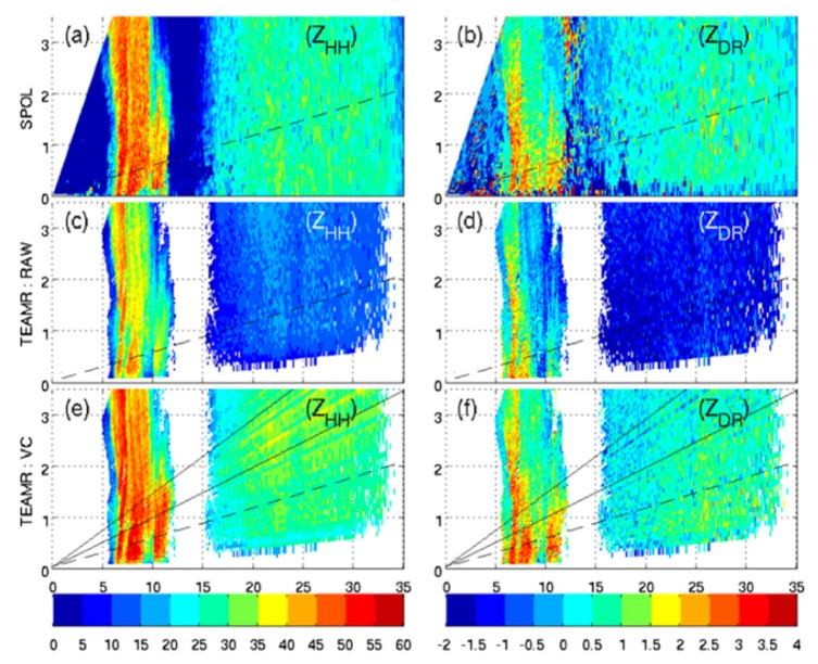
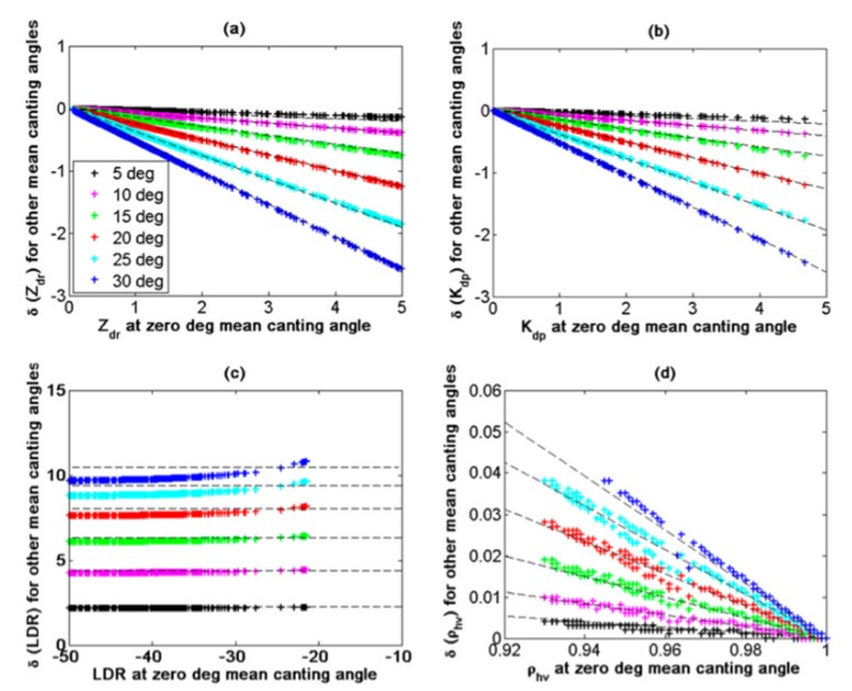
Due to the installation location, external structure of the R/V NOR1 and oceanic environment, the OR-POL needs to adjust the scanning strategy for various maritime precipitation. The optimal scanning strategy and signal processing procedures of shipborne radar for different weather scenario will be investigated. The combination of PPI (Plan Position Indicator), RHI (Range Height Indicator) and vertical pointing scan can provide distinct characteristics of precipitation system over ocean. The optimization of hybrid-scanning strategy will be investigated. In terms of the data quality of shipborne radar, the attenuation correction of shipborne radar will be applied and examined. The PhiDP-based and variational-based algorithm will be applied to shipborne radar data. An example from Chang et al. (2014) is shown in Fig. 1. The corrected mobile radar (TEAM-R) measurements (ZHH and ZDR) are greatly improved (Figs. 1e and 1f) from raw data (Figs. 1c and 1d). The corrected data is comparable to SPOL measurements (Figs. 1a and 1b). The measurement error from insufficient ship-motion compensation can be corrected as suggested by Thurai et al. (2014). The look-up table of ship-motion compensation correction for ZDR, KDP, LDR and Rhv can be corrected as shown in Fig. 2. It is essential to develop the shipborne radar data processing algorithms.
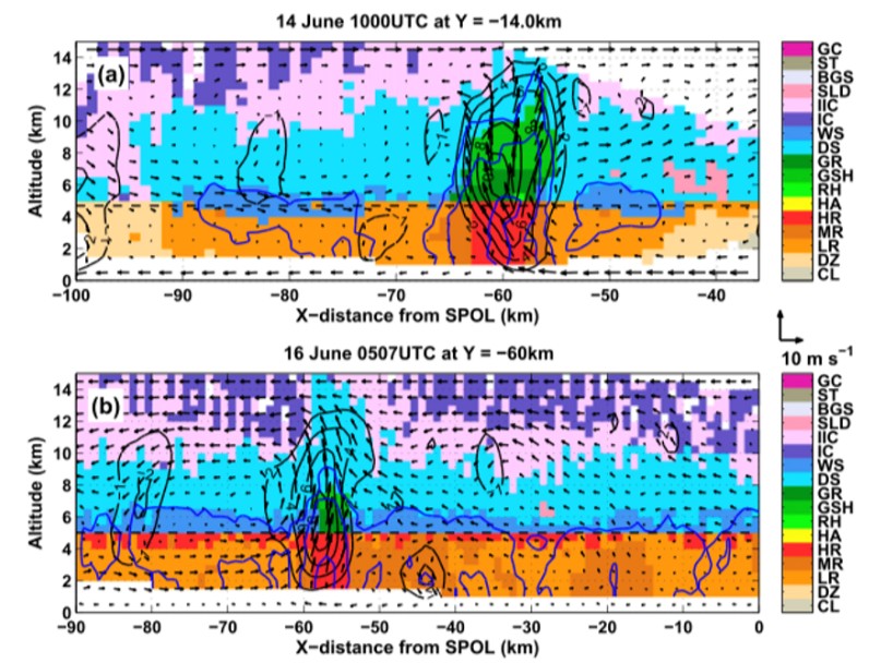
After quality-control procedures, the radar data can be applied to derive various meteorological products. The QPE algorithms for maritime precipitation system will be developed. The rain map product can be derived every 5 to 10 minutes. The shipborne Micro-Rain Radar (MRR) can provide the drop size distribution measurements for deriving QPE coefficients. The microphysical (Particle Identification, Vivekanandan et al., 1999) and kinematic (3D-wind fields, Liou and Chang, 2009) fields can be derived as well (Fig. 3). The data from shipborne radar can not only used for scientific research, the coordinate observation along with the CWB radar network can beneficial for hazard warning and disaster reduction. In addition, the mobility of shipborne radar can be used to off-shore wind energy study including wake-effect, wind turbine operation and wind power validation. Most importantly, the shipborne radar can participate international field campaign by conducting joint radar observation.
To operate the first shipborne meteorological radar in Taiwan is a challenging task and also an opportunity. There are only two countries have shipborne radar consistently operate for research. Collecting radar data at open ocean with constantly moving R/V NOR-1 will require substantial effort to ensure the data quality of radar data. Through this project, the scientist devoted into shipborne radar operation can be well trained. The maritime precipitation over vast ocean around Taiwan can be studied by shipborne radar. The data can be used for various of topics, including improvements of numerical model, validation of Formosa satellite data, study of air-sea interaction, etc.
Tasks
A quasi-operational mode of the shipborne radar observations is planned to achieve in four years. The primary annual tasks are:
- Year 1 :
- Development of radar data quality control procedures including attenuation and ship-motion compensation correction.
- Year 2 :
- Development of meteorological products for maritime precipitation systems.
- Year 3 :
- Evaluation of the performance of the radar data quality control procedures. Assessment of the radar data quality.
- Year 4 :
- Improvement of meteorological products for maritime precipitation systems.
